Offline-First Desktop GIS

The AI-Powered GIS Built for Modern Field Operations

Enterprise-grade desktop GIS with true offline capability, DuckDB-powered analytics, and AI-driven insights. Full ESRI compatibility at a fraction of the cost.

10-100x
Faster Queries
100%
Offline Capable
$2,995
Per Seat / Year

Why GeoAnalytics Pro?

One application. Complete workflow. From field to analysis.

True Offline Operation

Fully functional without internet connectivity. No cloud dependency for core features. Designed for disconnected, denied, and austere environments.

Learn more →

Unmatched Performance

DuckDB-powered analytics deliver 10-100x faster spatial queries than traditional databases. Query billions of rows in seconds, locally.

Learn more →

AI-Powered Intelligence

RAG document Q&A, computer vision object detection, predictive analytics, and terrain hazard analysis — all running locally or hybrid.

Learn more →

Professional Field Collection

GNSS/GPS with RTK support, position averaging, offset measurements, and multi-constellation receiver integration.

Learn more →

Video Analytics & FMV

Multi-stream processing with AI object detection, tracking, behavioral analysis, and full-motion video exploitation.

Learn more →

Modern Data Formats

Native support for COG, COPC, PMTiles, FlatGeoBuf, GeoParquet, 3D Tiles, and SLPK SceneServer.

Learn more →

Built With Modern Technology

Go backend, React frontend, DuckDB analytics — unified in a single desktop application

GeoAnalytics Pro Architecture Diagram
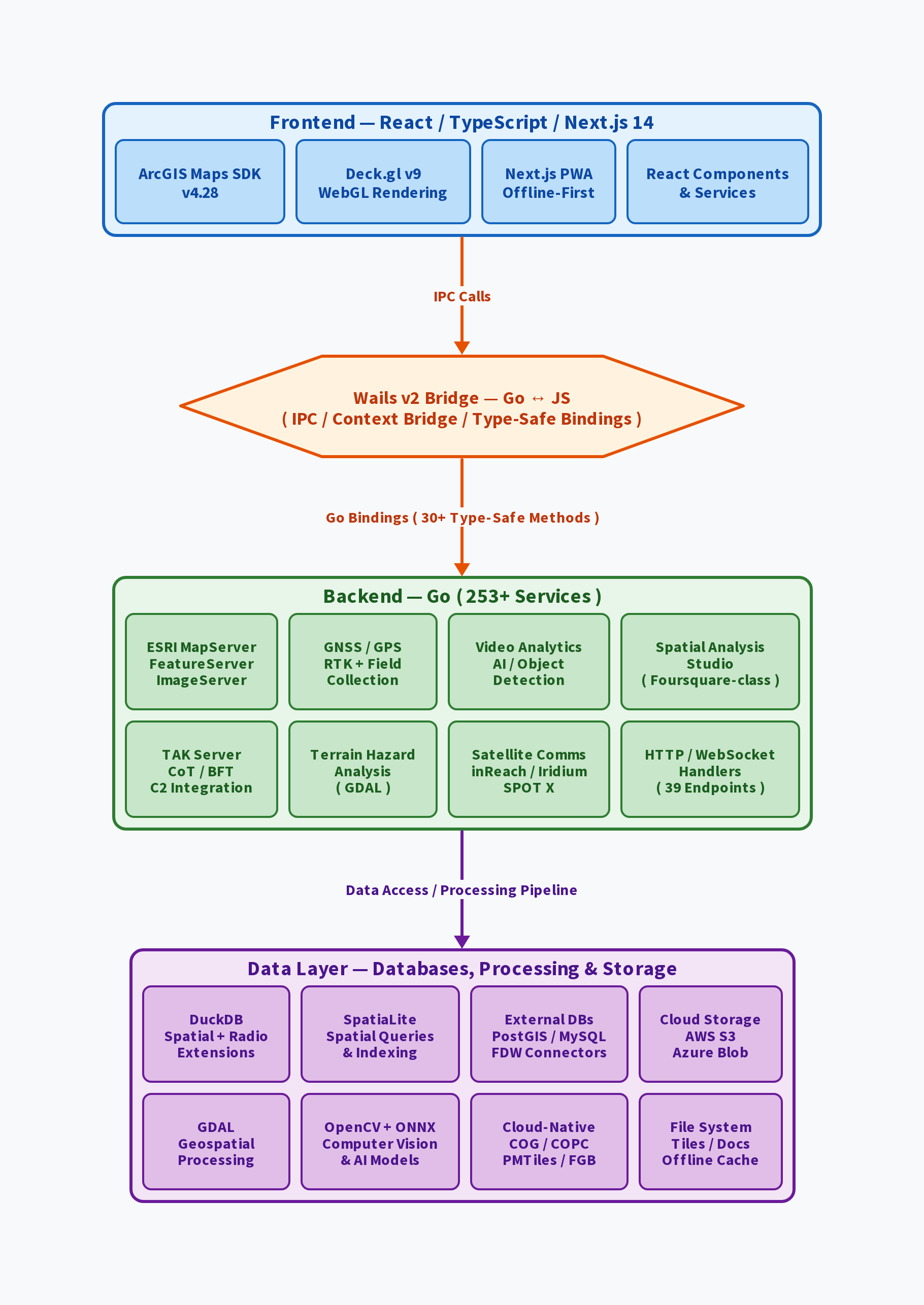
Four-tier architecture: Frontend, Wails Bridge, Backend Services, Data Layer

Purpose-Built for Critical Operations

Trusted by organizations across demanding environments

Military & Defense

  • Tactical operations and mission planning
  • Terrain analysis and hazard assessment
  • 100% offline operation required
  • CMMC compliance ready

Emergency Response

  • Real-time situational awareness (COP)
  • Disaster response coordination
  • Multi-agency collaboration
  • Budget-conscious alternative

Engineering & Construction

  • Site surveying and data collection
  • As-built documentation
  • Equipment integration (GNSS, drones)
  • Remote job site sync

Utilities & Infrastructure

  • Asset management and inspection
  • Maintenance planning
  • Field operations optimization
  • Real-time equipment tracking

How We Compare

ESRI-compatible performance at a fraction of the cost, fully offline

Feature GeoAnalytics Pro ESRI ArcGIS Pro QGIS
Price (annual/seat) $2,995 $1,500 – $4,500 Free
Offline Capability Full Limited Yes
Performance (Large Data) Excellent Good Poor
AI Integration RAG + CV Cloud-only No
Field Collection (GNSS) Integrated Separate app Plugins
Video Analytics Built-in No No
Modern Data (COG/COPC) Native Partial Partial
Enterprise Support Yes Yes Community

Modern Stack, Maximum Performance

Leveraging cutting-edge tools for reliability and speed

Backend

  • Go (Golang) for superior performance
  • Wails framework for native desktop
  • DuckDB for analytics (10-100x faster)
  • GDAL for geospatial processing

Frontend

  • React with TypeScript
  • Next.js framework
  • ArcGIS Maps SDK for JavaScript
  • DeckGL for WebGL visualization

Data Formats

  • COG (Cloud Optimized GeoTIFF)
  • COPC (Point Clouds)
  • PMTiles, FlatGeoBuf
  • 3D Tiles, SLPK SceneServer

AI & Analytics

  • RAG (Retrieval-Augmented Generation)
  • Computer Vision (Object Detection)
  • Terrain hazard analysis
  • Predictive analytics

Ready to Transform Your Field Operations?

Request a free demo and see GeoAnalytics Pro in action. No credit card required.

Request Free Demo

Request a Free Demo

See GeoAnalytics Pro in action. Our team will reach out within 24 hours to schedule your personalized demo.